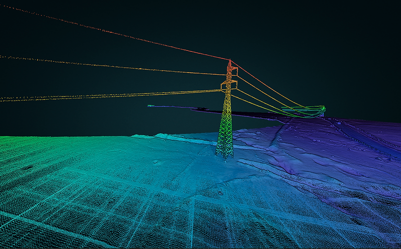
top of page

LIDAR Mapping

LiDAR (Light Detection and Ranging) is a laser-based remote sensing technology. Its operation consists of: it emits a laser pulse on a surface, catches the reflected laser back to the LiDAR pulse source with sensors, measures the time laser travelled and calculates the distance from source. 


Integrated into an unmanned aerial vehicle (UAV), LiDAR a GNSS receiver to provide accurate geodata about the sensor’s position (latitude, longitude and height) and an inertial measurement unit (IMU) to define the precise angular orientation of the sensor according to gravitational force. All these elements make it possible to form a complex three-dimensional map of the surveyed surface, called 3D point cloud.  

Features
Applications
Deliverables
Multimedia

Surveying Control Systems Ltda. uses the YelowScan Vx-15 LiDAR system, which has a Riegl miniVUX-1UAV laser scanner and an Applanix APX-15 UAV GNSS-Inertial solution, integrated into a DJI Matrice 600. 


Its main features are:  

  • Direct survey method, doesn’t require software to interpolate data. 

  • Not affected by weather in non-extreme conditions. 

  • Doesn’t have problems double heights, as happens in photogrammetry. 

  • Able to survey catenaries in high, medium and low voltage towers. 

  • Flight capacity in day and night. 

  • Precision of 1.0 cm. 

  • Accuracy of 1.5 to 5 cm. depending on the flight height. 

  • Surveys 200-300 hectares per day.  

  • Emits 100,000 pulses per second and each shot has up to 5 echoes. 

bottom of page